
Gusty winds and mountain snow: What to expect weather-wise through Saturday in SW Montana
Gusty winds and mountain snow are still on track to affect most of southwestern Montana Thursday through Saturday evening, according to National Weather Service forecasts.
Wind gusts were measured largely between 30 and 50 mph from Anaconda east to Butte and Whitehall and down to Dillon on Thursday. Some higher gusts up to 60 mph were reported Thursday morning east of Virginia City and along U.S. Highway 287.
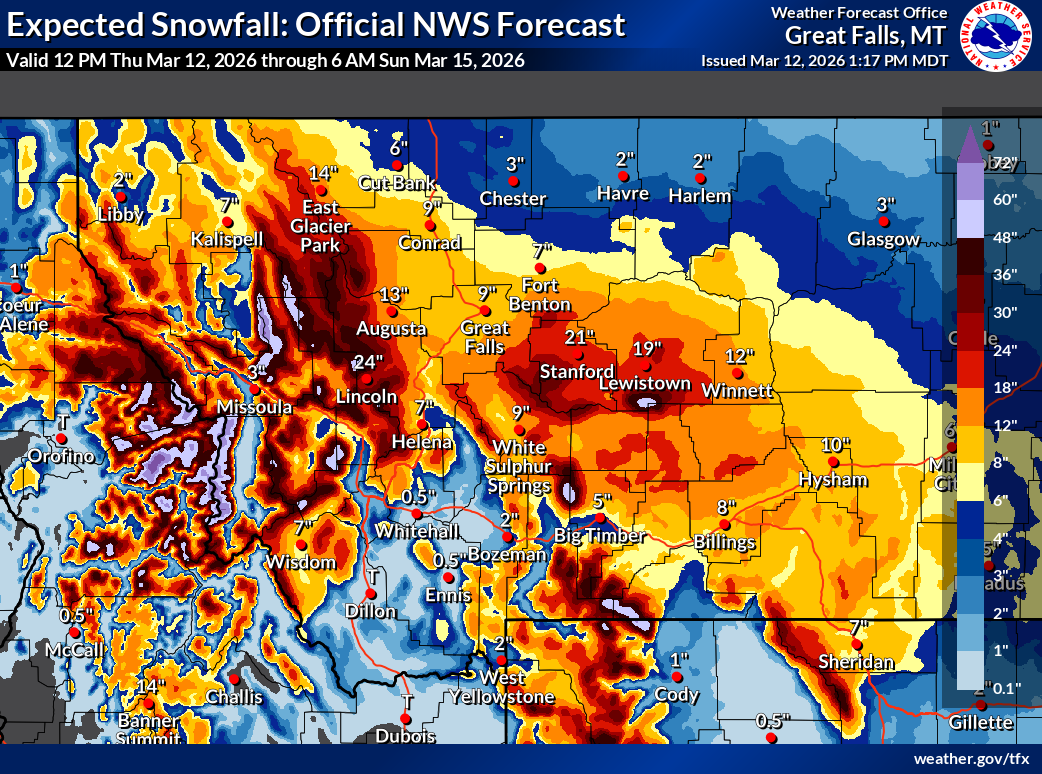
And while Butte isn't expected to get much snow in the storm, other areas along the Continental Divide could measure it in feet by Sunday, according to forecasters.
Butte-Silver Bow, Anaconda-Deer Lodge, Granite and the northern half of Beaverhead counties are all under winter storm warnings through Saturday afternoon, with 8 to 16 inches of snow expected in the mountains, including the Pintlers, Pioneers and Tobacco Roots, and some snow in the lower valleys.
Though snow will fall over the next couple of days in Butte, accumulations are only expected to reach an inch or two. Homestake Pass is expected to see around 3 inches through Saturday, according to the National Weather Service in Missoula. However, Lost Trail Pass could see upwards of of a foot and a half of snow from the storm, forecasters said Thursday.
Whitehall, Dillon and Ennis are likely to only see up to an inch of snow. Philipsburg and Drummond could see about 5 inches in the storm, according to the NWS.
The Elk Park area down to Boulder could also see 8 to 12 inches of snow, with up to 18 at the highest mountain peaks, the NWS said Thursday afternoon.
Georgetown Lake could see 10 to 20 inches of snow, the NWS said. Someone reported 8 inches of new snow 4 miles north of Polaris on Thursday morning.
“A highly complex series of events is unfolding through the weekend,” National Weather Service Missoula forecasters wrote Thursday morning.
Forecasters said winter conditions will exist along I-90 from Butte north to Missoula as temperatures cool and that the valleys in Granite and Powell counties could see 1 to 4 inches of snow through Friday morning.
By Saturday morning, temperatures are expected to fall and another round of winds gusting up to 35 mph will move into the area, along with more snow. Bands of snow are expected Saturday afternoon from the Idaho border east to Powell County, and roads could quickly freeze as heavy snow falls, the NWS said.



Comments ()