
National Weather Service forecasting heavy rain, possible flooding this weekend
The National Weather Service office in Great Falls has issued a flood watch and is forecasting heavy rain for large swaths of Montana this weekend, with up to 3 inches possible in some places.
According to meteorologist James Brusda with NWS, the widespread rain and mountain snow is expected to start Saturday and linger through Monday. The heaviest rainfall will likely hit north-central Montana, and temperatures will be much cooler than in recent days.
The excessive rainfall and subsequent snowmelt could cause the flooding of rivers, creeks and low-lying, flood prone places, the NWS said Friday. The greatest impacts will be along creeks and rivers emanating from the Rocky Mountain Front, including but not limited to the Sun River, Marias River and Saint Mary River. Officials warn rural roads may become impassable.
“Some of the bigger rivers are forecast to rise near or go into action stage this weekend/early next week, however, no river is currently forecast to go into flood stage,” Brusda said. “That could change as newer information comes in.”
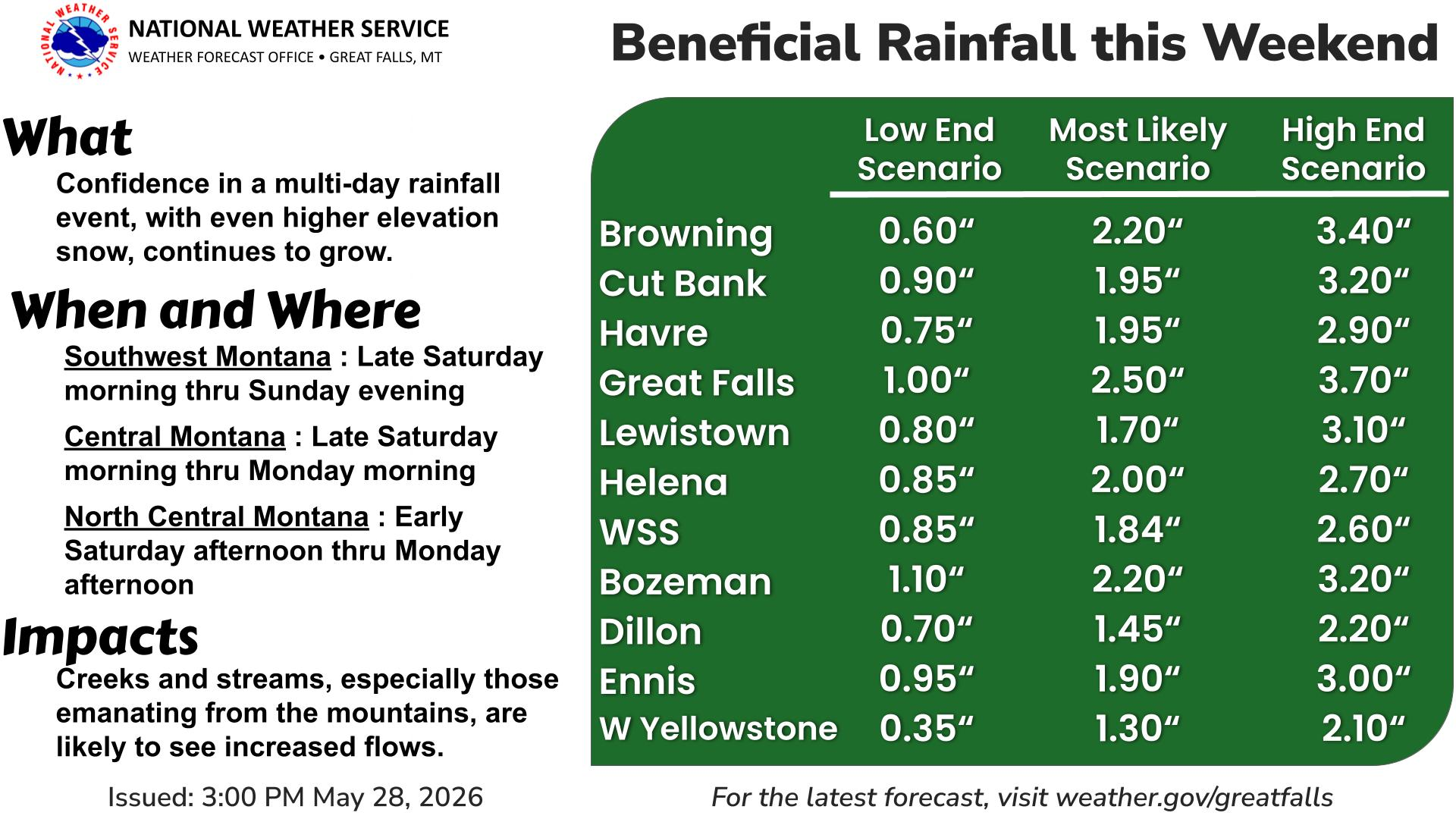
Overall, forecasters are expecting 1 to 3 inches of rain in most places, but there is a 10% chance for 4 inches along and west of the I-15 corridor in north-central Montana.
“Over the weekend, the probability of 2 inches of rainfall is about 60 percent west of a line from Great Falls to Havre,” Brusda said. “The probability for 3 inches of rain is generally less than 10 percent. Thus, a few locations will receive close to 3 inches of rain, but overall there is a 90 percent chance most areas will see less than 3 inches of rain.”
Helena is expected to see somewhere between 0.85 inches and 2.7 inches of rain, and forecasters expect about 1.6 inches in Butte.
There is also a 50% probability for 2 inches of snow for elevations above 7,000 feet.
According to Brusda, 2-inch rainfalls in a two-day period happen about every two-five years in the Great Falls area, and a 3-inch rainfall in a two-day period also happens about every two-five years west of Augusta.
“Thus, the spring storm that we are forecasting this weekend is on par for a fairly common spring storm,” Brusda said. “It is just that we have not had a storm like this in a few years.”
For Tuesday through next Friday, forecasters are calling for a gradual warming trend, but there will continue to be a chance for scattered showers and thunderstorms most days.



Comments ()